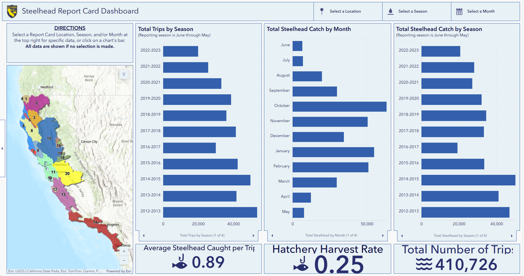
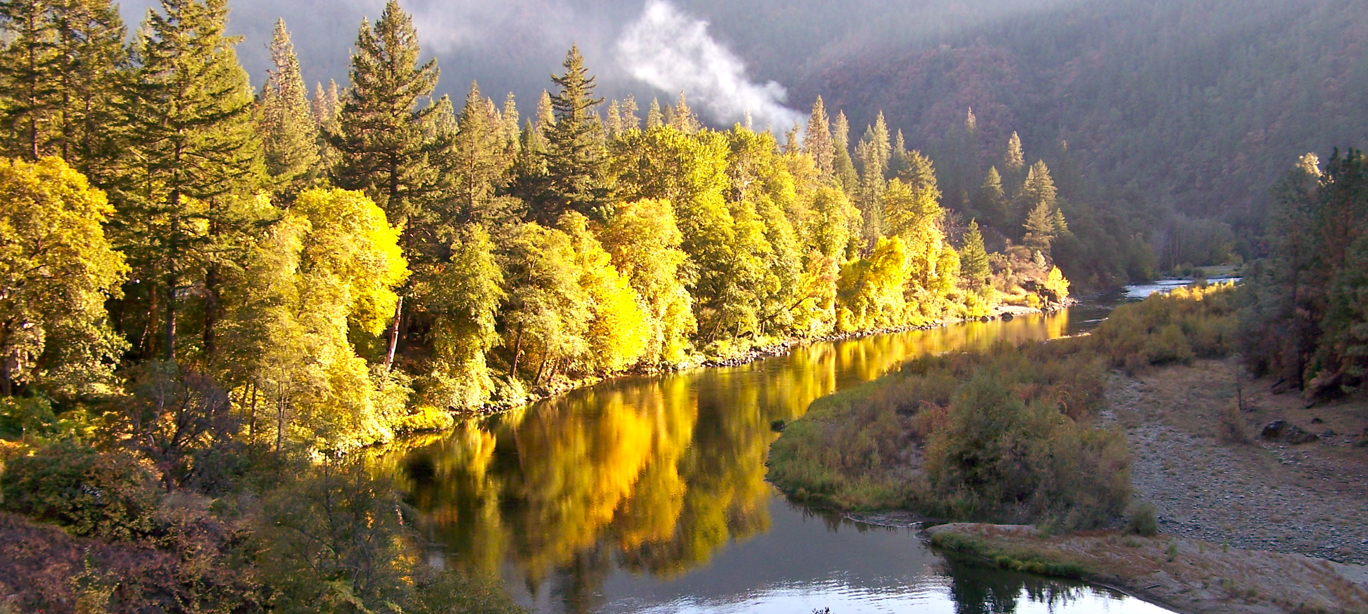
California Department of Fish and Wildlife Steelhead Report Card Dashboard
The California Department of Fish and Wildlife (CDFW) tracks steelhead angler effort and success through a reporting program. This reporting program consists of a mandatory report card that all steelhead anglers need to have in their possession while fishing. Anglers record each day that they fish, where they fish, how many fish they catch, and whether those fish are from a hatchery (determined by the lack of an adipose fin, which is removed by hatchery staff before the fish is released), or were spawned in the wild (determined by the presence of an adipose fin).
Each year, anglers are required to send these report cards back to CDFW, either physically or by entering the information online.
After many years of collecting data, CDFW recently released a compilation of raw summary data for the period of 2012-2023 (linked here). The data set can be sorted by area (the Trinity River is one of 20 river systems or regions), season, or month, and shows the numbers of fishing trips, the number of hatchery steelhead caught, and the number of wild steelhead caught.
The Klamath River and tributaries (except the Trinity River) stands out as an exceptional fishery. The Trinity River is not too far behind it among the 20 steelhead fisheries in the state.
It’s important to understand that while the raw data is informative, it is only a starting point toward understanding the fisheries. For example, in many systems, including the Trinity, hatchery production has changed substantially over the time period that the dashboard shows. Some hatcheries have reduced steelhead production by as much as 40%, which has an obvious bearing on the average number of steelhead caught per trip. Conversely, this data set covers two of the most severe droughts that Northern California has ever experienced. Droughts can leave the smaller tributary streams, which are usually off-limits to fishing because steelhead prefer to spawn in smaller streams, too dry for fish to migrate into. So, they remain in the mainstem river where people can catch them more readily than in normal or wetter years when they would have migrated into their spawning streams earlier. Tribal harvest methods, too, have changed in this time period and are much more selective for hatchery steelhead (identified by their lack of an adipose fin) over wild steelhead.
Still, this dashboard can be very useful for planning where and when to go on a steelhead fishing trip. And steelhead anglers should be happy to see the data that they carefully record and report is going to good use!
Rivers are dynamic ecosystems shaped by multiple interacting and overlapping physical and biological processes. A fundamental aspect of a river’s ecology is sediment, which is the foundational underpinnings of habitats, influence for water quality, and support for wildlife. In this article, we explore terminology and features of Trinity River sediments, the building blocks of our river system.
What is Sediment?
Although it might seem obvious, all sizes of rocks fit into the larger family of sediments. Sediments are inorganic particulates that can be transported by water, wind, or ice and deposited and perhaps stored for long periods of time in a particular location. In rivers, sediment is further classified according to its diameter and composition:
Clay (Particles smaller than 0.002 mm): Clay transports while suspended in the water column and when deposited can store nutrients aiding the growth of biology when organics chemically bind to individual clay particles.
Silt (Particles 0.002 mm to 0.063 mm): Silt also transports suspended in the water column and can affect light penetration and aquatic plant growth, just as clay particles do. Clays and silts that cloud the water also provide cover for fish, which use the cloudy water as protection from predators and tend to survive at higher rates when available intermittently.
Sand (Particles 0.063 mm to 2 mm): Sand provides a medium for plants to establish and grow. This sediment type provides rearing habitat for juvenile lamprey when located in deposits below large rocks or trees, and acts as a filter to benefit water quality when deposited between gravel particles.
Gravel (Particles 2 mm to 64 mm): Ranging from the size of a small blueberry to a large kiwi, gravel offers essential spawning grounds for fish and invertebrates.
Cobble (Particles 64 mm to 128 mm): About the size of an orange, cobbles are the framework for bar deposits in river systems. When settled they form a surface that is difficult to mobilize from and creates roughness that encourages small particles to deposit on top of them. While waters flow over through and under these habitat formations the sediments caught provide a diversity of flow in depth and velocity which species depend on in streams.
Boulders (Rocks larger than 128 mm): These create physical barriers in rivers that help form log jams, leading to diverse flow patterns and detailed habitats for a range of organisms.
Sources of Sediment in River Systems
Fine sediments entering the confluence of the North Fork and the East Fork North Fork after rain dropped on the the Monument Fire scar in July 2023.
Sediment can enter river systems through multiple processes, each contributing to the overall sediment dynamics and ecology of the river. Key sources of sediment include:
Erosion: As water flows over land soil and rock can move with it. Depending on the landscape and the soil content these sediments can be delivered to rivers, especially during heavy rainfall or rapid snowmelt.
Runoff: Rain and melting snow can wash fine sediments from forests, fields, urban areas, roads, and construction sites into nearby streams and rivers.
Bank Collapse: Riverbanks can be eroded by the current of flowing water, particularly in areas with high flow velocities, resulting in banks collapsing directly into the water.
Tributary Inputs: Creeks can contribute sediment as they flow into larger rivers, contributing sediments from their own drainage basins.
Human Activities: Construction, mining, and land clearing can disturb soil and rock, increasing sediment loads in nearby rivers. Deforestation can also enhance erosion rates when tree roots are damaged or destroyed, leading to hillslope failures into streams.
Natural Events: Floods, landslides, wildfires and volcanic eruptions can rapidly introduce large amounts of sediment into river systems, altering habitats and turbidity.
Aquatic Organisms: Organisms can influence sediment storage by building dams (beavers) or webs between gravels to capture food and fines (net-spinning caddisfly). Organisms can also mobilize sediment when building nests (salmon) or grazing for food, such as crayfish winnowing fine sediments from amongst gravels.
When the slope of a river is greater than 2 percent, water moves quickly over rocks and other obstacles creating rumbling mountain streams. Moving downstream as the valley walls open and slope decreases a pool and riffle river system will form. The creation of alternating river bends is based on physical obstacles along the river’s path and water velocity which will form deep (pools) and shallow (riffles). The dynamic plays a crucial role in the movement and storage of sediment as the river runs its course to the ocean. A few key terms:
Pools: Pools are deep areas of the river that form over time with flow velocity that scours (or digs) small unstable sediments from the area. Pools offer dynamic habitat during different times of the year that include a varied temperature column in the summer months when waters slow within the river. In winter, during high flows, pools are areas where faster water occurs. The increase in speed in pools relative to their companion riffles is what is responsible for pools scouring to depths found in summer.
Riffles: During lower flows that occur in late spring through fall, faster currents are found in riffles because the water surface is steeper on them. Riffles are nursery areas for macroinvertebrates and help oxygenate the water and benefit species that thrive in turbulent conditions. High flows in winter that scour pools deposit sediments from the scour on riffles downstream, and in this way a pool-riffle sequence of habitats is formed and maintained on alluvial rivers.
Salmon and Sediment Interaction
Salmon are a keystone species in freshwater ecosystems, and their interaction with sediment is crucial for their lifecycle. During spawning, female salmon seek out gravel beds on riffles and near the streams banks to lay their eggs. These gravel beds, composed of appropriately sized sediment, are essential because they provide the necessary water flow to provide oxygen to fertilized eggs, ensuring their development to the fry stage.
Additionally, the composition and stability of sediment in spawning areas can influence the quality of habitat available for juvenile salmon. Fine sediments, often stirred up during high flow events, can cover spawning habitats, suffocating eggs and reducing the overall success of salmon populations when fines are overly present.
However, Trinity River geomorphologists are learning that too few fines also pose survival risks to salmon. When spaces between gravels where eggs are spawned are left open, turbulence is created through flow within the salmon nest and can jiggle eggs causing abrasion to the egg membrane, leading to mortality. Too few fines can also cause surface flows in a river to be conveyed entirely through a bar, sieving off the juvenile salmon onto dry bar surfaces for predation by birds.
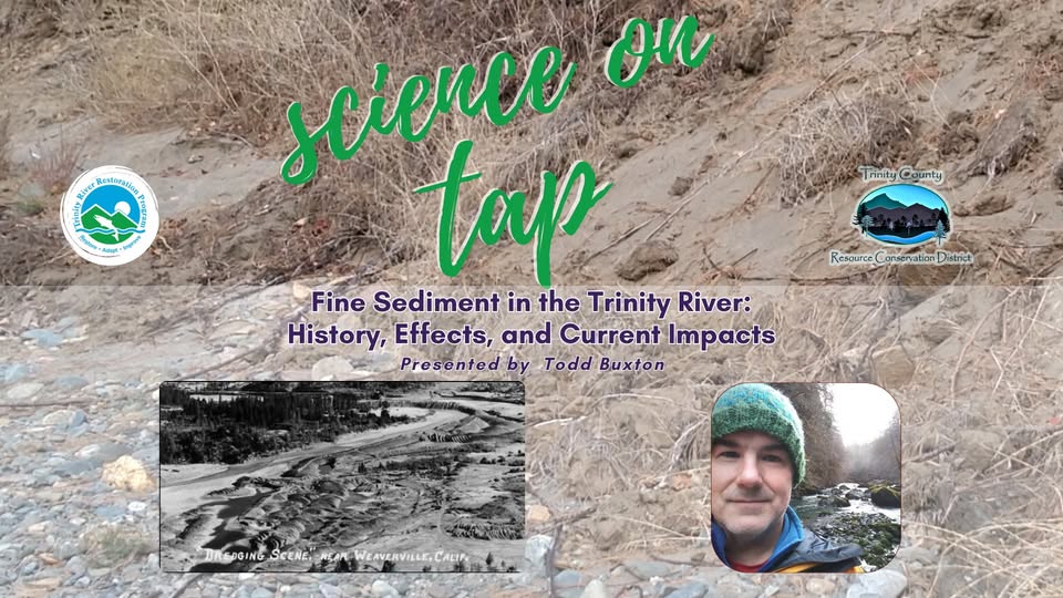
Join us Feb. 26 for Science on Tap featuring Dr. Todd Buxton for “Fine Sediment in the Trinity River: History, effects, and current Impacts”
Maintaining a balanced sediment regime within pool and riffle systems is essential not only for river ecology but also for the conservation of salmon, whose life cycles are intricately tied to the health of their sediment-rich habitats. As we learn more about these systems, it becomes increasingly important to recognize how sediment influences river health and ecology, guiding conservation efforts to ensure the survival of these vital ecosystems.
We invite you to join us Wednesday, Feb. 26 for Science on Tap! Dr. Todd Buxton will dive into Trinity River Fine Sediment, history, effects and current impacts. The event is held at the Trinity County Brewing Company and starts at 6pm.
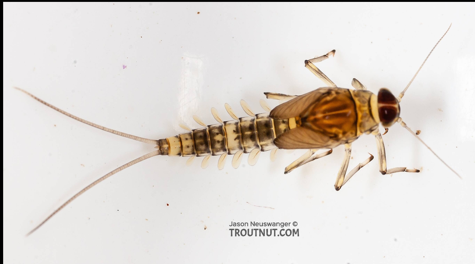
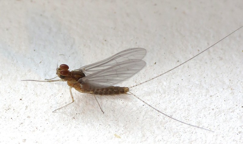
Mayflies from the family Baetidae are this month’s ‘bug of the month’. Commonly known as blue winged olives by fly fishermen, Baetid mayflies are small (<10mm) and can be extremely prolific. In addition, they grow rapidly and can have multiple generations within a year (known as multivoltine). This means that you can see adult Baetid mayflies during most of the year although they are especially apparent during the winter in early spring when few other bugs are hatching.
Photo Credit: TroutNut.com
Baetid mayflies are exceptionally adept at colonizing new habitat. They are extremely good swimmers (for a bug) and are known for undertaking what is known as behavioral drift. Behavioral drift is a strategy where macroinvertebrates enter the flow of the river voluntarily to seek out new habitat. Short life cycles, excellent swimming ability, and the propensity to undertake behavioral drift allow them to settle new habitat like when high flows inundate floodplains.
They are often the first to colonize a new area due to their swimming skills and their preference for shallow, slow water. These newly formed areas grow algae very well which is the primary food source for Baetid mayflies. They can often exploit newly formed habitat within a few weeks and live their entire life cycle within 12 weeks before other bugs get a chance to settle in an area. Seasonal inundation of floodplains are extremely important to Baetid mayflies success. Juvenile salmon have evolved to depend on the seasonal inundation of floodplains because of the presence of Baetid mayflies, which they eat for food.
Chris Laskodi, M.S., Fish Ecologist – Yurok Tribal Fisheries Department
Chris serves as the fish biologist/ecologist for the Trinity River Restoration Program in the program’s Science branch. Chris has worked on the Trinity River since 2015, previously serving as a fish biologist for the Yurok Tribe and a fisheries technician for the US Fish & Wildlife Service. Chris holds a B.S. in Wildlife, Fish and Conservation Biology from the University of California, Davis and a M.S. in Aquaculture/Fisheries from the University of Arkansas at Pine Bluff. In his free time, Chris enjoys taking friends and family fishing on one of the many watercraft available to him.
Rivers are vital parts of our ecosystems, and they behave differently depending on the climate they flow through. In a Mediterranean climate, which is characterized by hot, dry summers and variable, wet winters, river flow can be particularly interesting. Let’s explore some important terms and concepts related to river flow that is represented in our unique climate and system.
John Hubbel
What is River Flow?
At its most basic, river flow, or discharge, is the volume of water that moves through a river over a specific period of time. On the Trinity River, flow is typically measured in cubic feet per second (CFS). Currently flow rates are measured in a few locations above and below Trinity and Lewiston Dams. Discharge on the Trinity River at Lewiston has been measured daily since 1911, when Model T’s were just rolling off of the assembly line!
There are very few rivers in California that experience full natural flow. Most Northern California rivers are managed through dams that generate power, create water diversions, or hold back water for later use. Dams block upstream deposits of water, wood and sediment and when managed narrowly have caused significant harm to riverine ecology downstream.
Understanding river flow both pre-dam and post-dam helps river ecologists to compare current management with the pre-dam natural conditions that species and their ecology developed within. This strategy aims to deepen understanding of the natural environment to provide favorable conditions for plants, wildlife, and people that depend on the river.
Why is River Flow Important?
The Trinity River’s flow is crucial for many reasons:
Ecosystems: Flow influences the types of plants and animals that live in and around the river.
Water Supply: The Trinity River provides drinking water, supports economic development, supplies irrigation for agriculture and generates power for millions of Californians.
Recreation: The Trinity River supports activities like fishing, boating, hiking, gold panning, wildlife viewing and swimming.
Key Terms Related to River Flow: Managed vs Natural
Natural Seasonal Flow: Although highly variable from year to year, undammed rivers in a Mediterranean climate, tend to exhibit seasonal patterns. During the rainy winter months, flow rates typically increase due to precipitation, the size and magnitude of that increase depends on seasonal patterns and the frequency of storm events. In the spring, snow in the mountains melts adding flow to the Trinity River and its watershed. Conversely, in summer, flow rates tend to slowly decrease as the dry season progresses.
Natural Base Flow: This is the normal level of water flow in a river during dry periods. It usually comes from groundwater and keeps the river flowing even when there hasn’t been rain for a while. In a Mediterranean climate, base flow can be low during the summer months due less water in the system and high evaporation rates. Baseflows are important for cold-blooded aquatic species like foothill yellow legged frogs who utilize slow water for rearing and then populate riverside riparian areas as adults.
Hydrograph: A graph that illustrates how the flow of water in a river changes over time. It shows time on the horizontal axis and the flow rate, usually measured in cubic feet per second, on the vertical axis. As the line on the graph rises, it indicates an increase in river flow (like after rain), and when it falls, it represents a decrease (such as during dry periods). Hydrographs are important for managing water resources, studying weather patterns as well and ensuring that environmental flow needs are met in regulated river systems.
Natural Surface Runoff: After it rains, water flows over the land and enters rivers. This is known as surface runoff. Winter rains in the Trinity watershed typically lead the tributaries and the Trinity River (below Douglas City) to a spike in flow. However, the impact is highly dependent on the water year, ground saturation and snow accumulation. Surface runoff provides additional wood, leaf litter and sediment to rivers which are the building blocks for healthy habitat creation in the Trinity system.
Over-bank floods: When there is a lot of rain in a short period, rivers can overflow their banks, causing over-bank floods. On the Trinity River over-bank floods are more likely to occur during the wet season and provide important ecological functions, including to Trinity River fish. These flows improve soil quality, provide prime growing grounds for aquatic insects and other fish food and help to reset the form of the river’s main channel through scour.
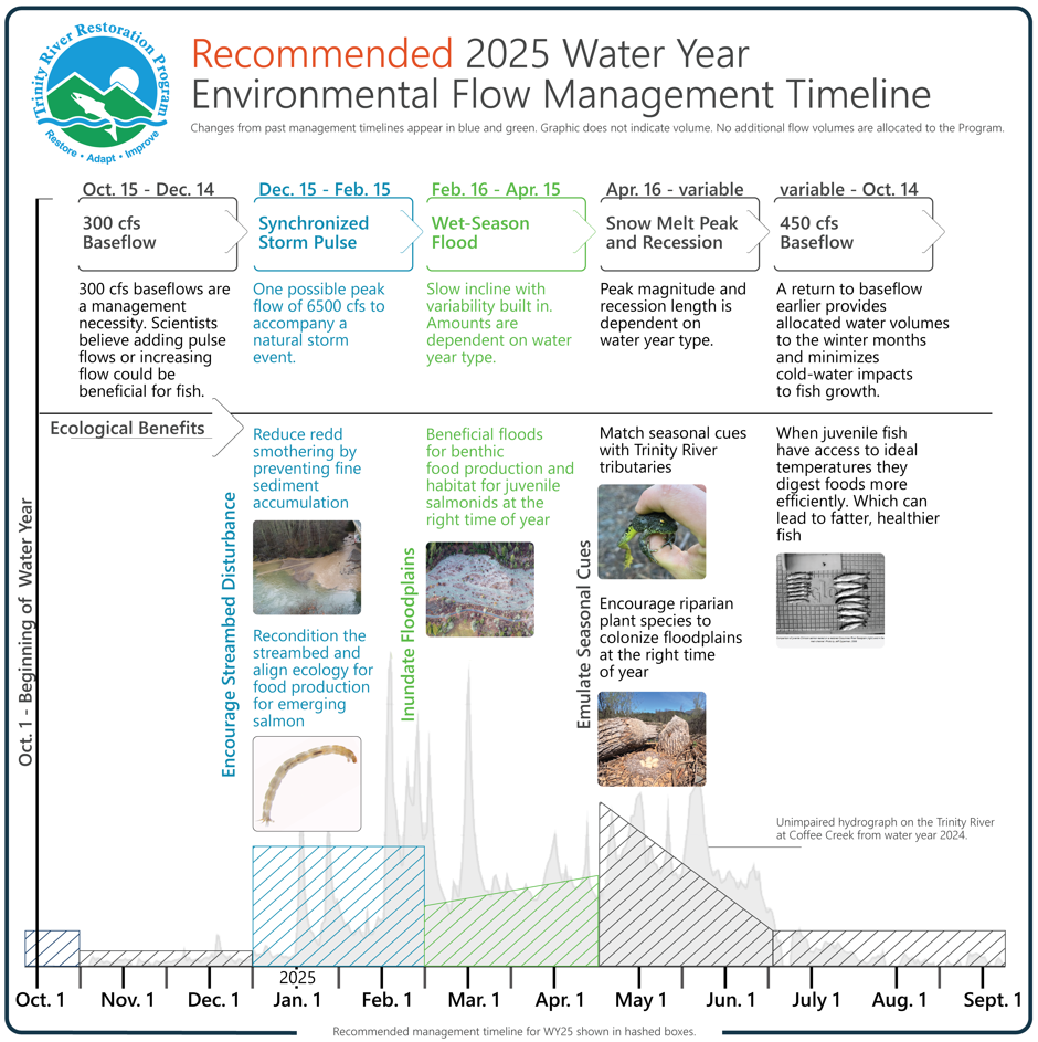
Environmental Flow: Is a management term that identifies the quantity and timing of water needed to sustain the health of river ecosystems, particularly downstream from a dam. Managing environmental flow is important for maintaining habitat for Trinity River salmonids and other wildlife that depend on the river. Within the environmental flows framework there are many methods for implementation. Since 2004, the Trinity River Restoration Program’s method for environmental flows were based on functional implementation of three periods, a summer baseflow (450 CFS), a fall/winter baseflow (300 CFS), and a spring snowmelt mimic hydrograph. Since 2016 local scientists have advocated to adapt this method by adding variable flows to the wet-season months (December – April) for the benefit of growing healthier juvenile salmonids.
Recommended Periods within the Environmental Flow Timeline for Water Year 2025
1. December 15 – February 15 – Synchronized Storm Pulse
A dam release synchronized to a natural storm event. The release is triggered by a CNRFC forecast for the Trinity River above North Fork that rises to 4500 CFS or more. Once initiated, the release would be triggered even if the forecast is reduced. The primary purpose is to reduce redd smothering by preventing fine sediment accumulation from tributaries, to maximize the synchrony between tributaries and the mainstem of the river, as well as recondition the streambed and align the ecology for salmon food production.
2. February 16 – April 15 – Wet Season Flood
Depending on forecast water year type in the California Department of Water Resources February B120 forecast and whether a synchronized flow has occurred, the Program may schedule flows above baseflow in the Feb. 15 to Apr. 15 timeframe. Depending on the March B120 forecast, the schedule may be adjusted as of March 15. The primary purpose of this is to inundate floodplains for aquatic food production and habitat for juvenile salmonids at the right time of year – similar to natural wet season flooding.
3. April 16 – Variable – Snowmelt Peak and Recession
The spring snowmelt peak and recession are an important annual migratory cue for both adult and juvenile chinook. The Program has implemented a spring snow-melt mimic release annually since 2004. CDWR April B120 forecast determines total volume of restoration flow releases. Water that has not been released for Storm Pulse Flows or Wet Season Flooding is scheduled for release during the Snowmelt Peak and Recession period. This schedule encompasses many purposes for river ecology and the salmonid life cycle.
4.Managed Base Flow
Baseflows released from Lewiston Dam to the Trinity River are currently managed at 450 CFS through the summer, shifting to 300 CFS on Oct 15 through the subsequent spring. This management strategy is a relic from the 1999 Flow Study and was put in place with the mindset that increasing baseflow in the summertime could help with river temperature management for migrating adult spring chinook. Flows reduce in the fall because temperature objectives are no longer needed. In addition, water managers leaned on water savings during the fall through the wet season so that accumulation in the system could be understood prior to use for diversions or river ecology. Fish biologists hypothesize that if current summer and fall management were adapted to a more natural hydrograph it may serve Trinity River salmonids and other wildlife better.
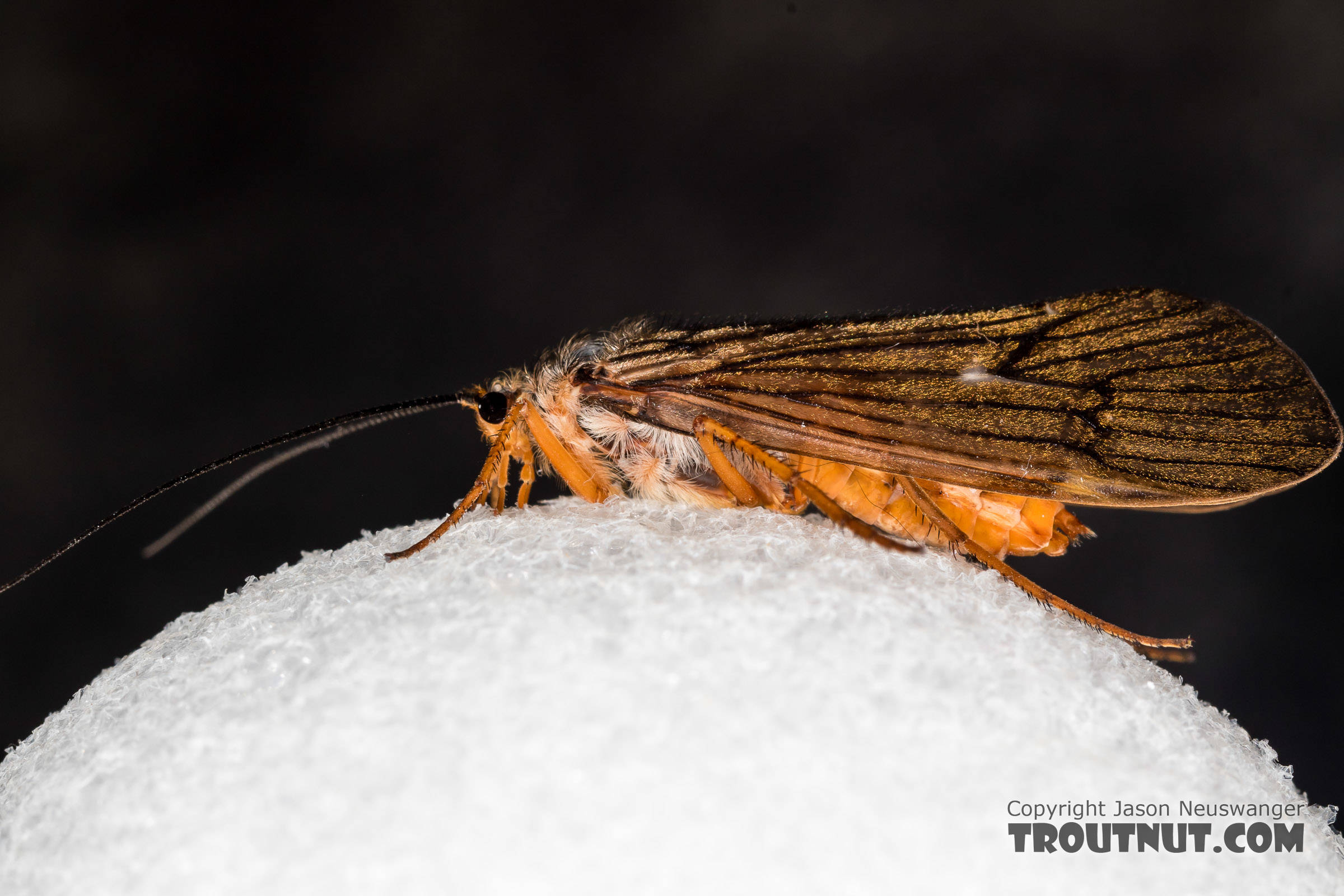
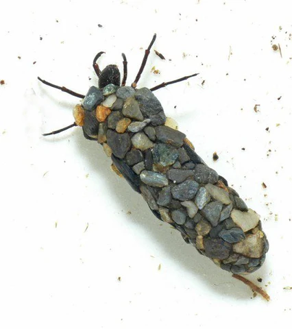
Dicosmoecus (dee-co-smee-cus) caddisflies are better known by the common name ‘October caddisflies’. These caddisflies are notable for there extremely large size (1-2 inches), their concentrated emergence window (October), and their abundance especially in streams containing anadromous fish. These characteristics make it one of the most important hatches to not only fly-fishermen, but to wildlife such as birds as well.
Dicosmoecus like other caddisflies have three life stages: larvae, pupae, and adult. Larvae build cases out of small rocks which serves as protection and their housing. They drag these cases around while foraging for food, mostly algae and detritus. Dicosmoecus are especially notable by the large distances they can cover (up to 25 meters per day) to forage (Resh et al. 2011).
They continually grow and have to build new cases as the old ones become too small. After molting five times (called instars), they attach their cases to the underside of rocks and began to pupate. After about a month of pupating, they cut a hole in their case and swim to the surface before shedding their exoskeleton one more time and becoming adults.
Caddisflies, unlike mayflies, will live for several weeks while they seek out a mate. You will often see them active at dusk and just after sunset. Keep a look out for the large moth-like bugs during sunset for the next few weeks.
References
Resh, V.H., M. Hannaford, J. Jackson, G.A. Lamberti, and P.K. Mendez. 2011. The biology of the limnephilid caddisfly Dicosmoecus gilvipes (Hagen) in Northern California and Oregon (USA) streams. Zoosymposia 5:413-419.
Images courtesy of Red’s Fly Shop and Troutnut.com
Chris Laskodi, M.S., Fish Ecologist – Yurok Tribal Fisheries Department
Chris serves as the fish biologist/ecologist for the TRRP in the program’s Science branch. Chris has worked on the Trinity River since 2015, previously serving as a fish biologist for the Yurok Tribe and a fisheries technician for the US Fish & Wildlife Service. Chris holds a B.S. in Wildlife, Fish and Conservation Biology from the University of California, Davis and a M.S. in Aquaculture/Fisheries from the University of Arkansas at Pine Bluff. In his free time, Chris enjoys taking friends and family fishing on one of the many watercraft available to him.
Prior to construction of dams on the Trinity River, flow and river temperatures were synchronized throughout the watershed with seasonal ecology. Storms and snow melt floods regularly altered the stream channel, transporting sediments, wood and rocks. Seasonally predictable disturbance helped maintain a healthy streambed and riparian forest. Disturbance was followed by growth, with wetted areas providing consistent habitat for insects, fish and frogs alike. Even though each year provided different conditions, there was predictability with which aquatic and riverine species, like salmon, evolved to exploit.
Since the foundational 1999 Trinity River Flow Evaluation Report, more than 20 years of scientific research within the Trinity River Basin and from rivers across the world have improved outcomes for Trinity River salmonids. This wealth of new and improved knowledge has made scientists within the Program increasingly aware that changes to flow management have the potential to increase the strength and resiliency of juvenile salmonids produced in the Trinity River.
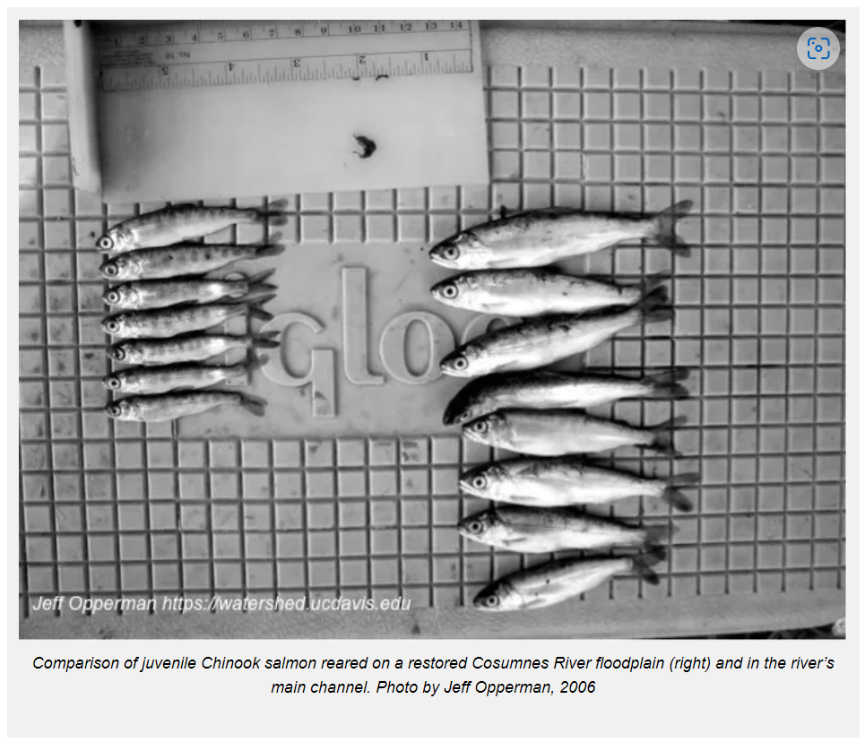
One important revelation is that elevated releases that continue through late spring and into the summer have kept water too cold for optimal juvenile salmon growth. Larger fish have a better chance of survival in the ocean, so improved flow management that can provide better temperatures for growth is likely to improve survival and subsequent adult returns. Further, Program scientists have found that the majority of young Chinook Salmon have already left the restoration reach by the time elevated spring releases provide access to restored habitats created by the Program over the last 18 years, including floodplains and side channels.
Many studies have shown that when floodplains and side channels get wet at the right time of year when juvenile salmon can use them, then they can take advantage of all the extra food that those habitats create. When fish can access important habitat, increase their food consumption, and have the right temperatures for growth, they can grow faster, get bigger, and survive better.
Recommendations for Change
Changes to Trinity River flow management to partially mimic the seasonality of natural flow were approved by the Trinity Management Council this past September. Program partners in our Flow Workgroup technical advisory committee developed a collaborative proposal that met ecological objectives and accommodated recreational considerations requested by Trinity County. The proposal also needed to adhere to existing environmental regulations. Following the affirmative Trinity Management Council vote in September, the recommendation is now awaiting approval by the U.S. Department of the Interior.
Water Year 2025 environmental flow management is designed to partially mimic natural seasonality so that river ecology can build around flow as it did prior to dams. These managed flows do not strictly follow the natural ecology of the watershed, but rather they represent management that strikes a balance between ecological needs, water availability, and other management and infrastructure constraints. Scientists hypothesize that adding pulse flows, increasing flow in winter, and decreasing flow in the spring and summer could be beneficial to Trinity River salmonids. However, there is no recommendation for this water year to reduce minimum baseflows in summer or fall.
First Recommended Change: Synchronized Storm Pulse
The first recommended sequential change is the two-month Synchronized Storm Pulse period (December 15-February 15) where there may be one peak flow of 6,500 cubic feet per second released from Lewiston Dam timed to match a natural storm event. This synchronized flow would consist of a rapid flow increase release held for a short period then reduced to 750 cubic feet per second. A synchronized storm pulse would only be triggered if the river is predicted to be at least 4,500 cubic feet per second near the North Fork Trinity River. No synchronized release would occur if the river is not predicted to reach that level between December 15 and February 15.
Winter storm pulses provide many ecological benefits, primarily by causing streambed disturbance. Sediments ranging in size from sand to large gravel are displaced and moved downstream, and wood in the channel can be moved or cause erosion in the channel that increases habitat diversity. Fine sediments rich in nutrients are also washed onto upland riparian areas that are typically dry. As waters recede, nutrients remain to help develop a healthy riparian community of plants and animals. For salmon, the disturbance from big powerful storms provides opportunity for small, soft-bodied bugs to proliferate, which are an excellent food source for small juvenile salmonids as they emerge from the gravel.
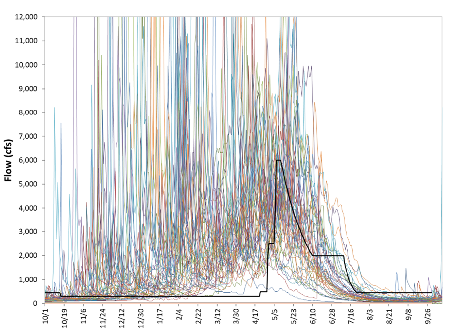
Pre-dam Trinity River flows at Lewiston (colored lines), and a typical normal water year flow release after 2000 (black line).
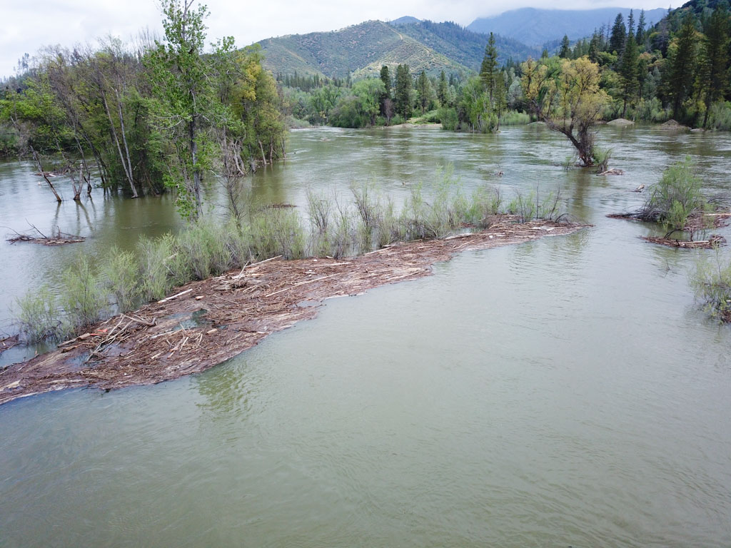
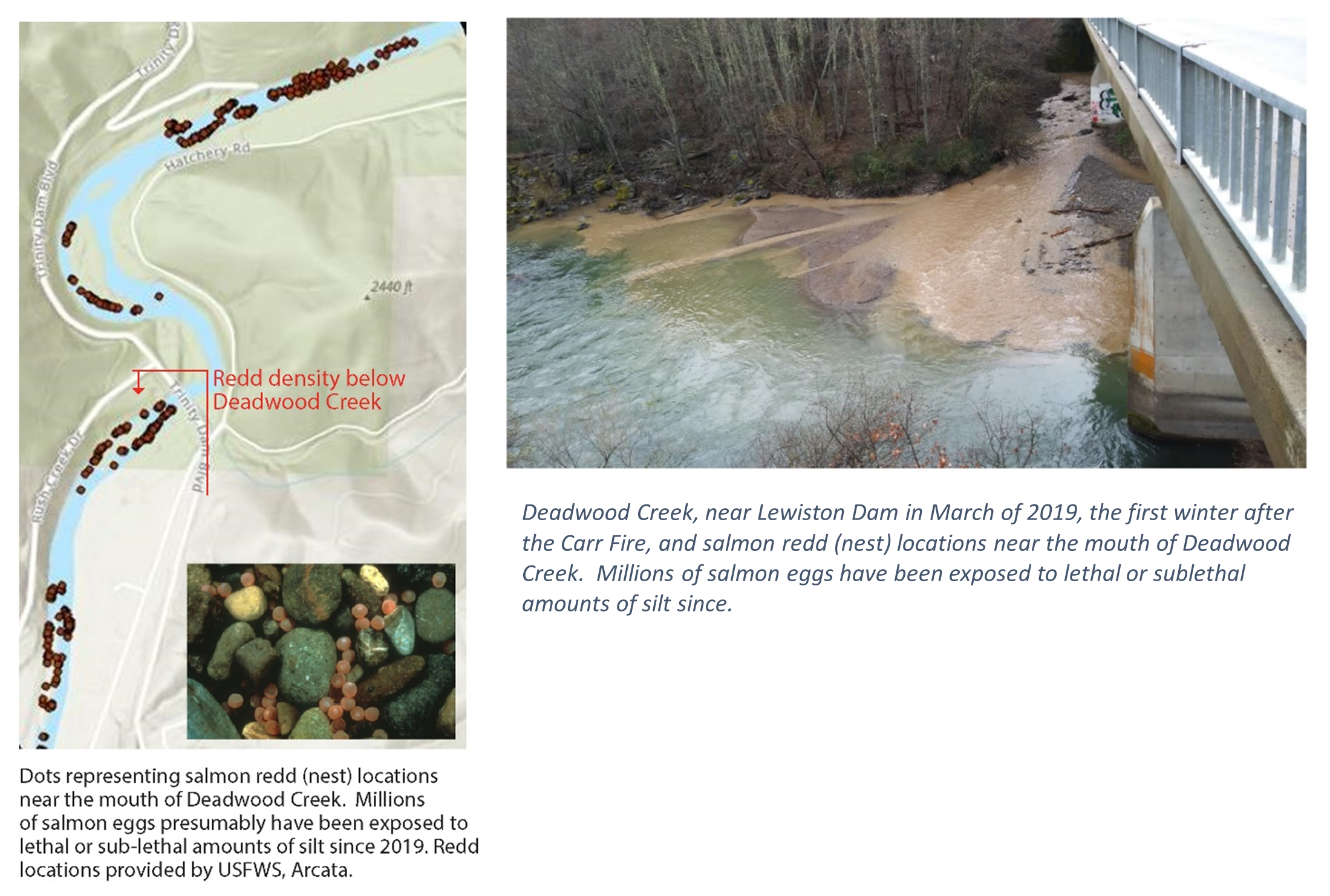
Since 1960’s, with very few exceptions, typical winter flow releases from Lewiston Dam have remained under 300 cubic feet per second. When big storms pass through, tributaries deliver trees, nutrients, and all sizes of sediment, which enter the Trinity River where flows are artificially low due to limited dam releases. Often there is not enough flow in the Trinity River to move these deliveries from tributaries, so they settle out quickly. Where Deadwood Creek enters the Trinity River, large fine sediment deposits from the 2018 Carr fire have immediately settled into slow waters in recent years resulting in two negative effects. First, the tributary delta has formed unnaturally, and second fine sediments have smothered and suffocated salmon and steelhead eggs in the gravel.
Second Recommended Change: Wet-Season Flood
The second recommended change is the two-month (February 16 – April 15) Wet-Season Flood period, during which dam releases would be elevated above the typical 300 cfs baseflow with some variability. The amount of water released during this period depends on seasonal snow and rain accumulation and a conservative forecast of inflow to Trinity Reservoir from the California Department of Water Resources (90% B120).
These beneficial floods push water onto floodplains and keeps them wet for months, which essentially converts terrestrial habitat into aquatic habitat just as salmon and steelhead begin to emerge from the gravel and populations increase. This seasonal aquatic habitat grows food for fish and provides slow water habitat for small fish to rest, grow, and escape many aquatic predators.
Oregon Gulch floodplain inundation in March 2024 provided habitat for millions of juvenile salmonids and other aquatic species. Aaron Martin, Yurok Tribal Fisheries Department.
Snow Melt Peak and Recession
The Snowmelt Peak and Recession period has been implemented on the Trinity River for the past 20 years. The action provides important migration cues for adult and juvenile salmonids. Peak flows can provide many of the benefits that winter storm pulse flows provide earlier in the year, resetting the base of the food web and delivering nutrients to riparian areas. Receding flows trigger spring Chinook Salmon returning from the ocean to migrate toward over-summer habitat. Additionally, juvenile salmon and steelhead migrate out of rivers, to the ocean, as habitat availability decreases with dropping flows.
Proposed changes to flow management in 2025 would use the same volume of water that has been available since 2000, so any water released for a synchronized storm pulse or wet season flood would be borrowed from the spring snow melt release. As a result, releases would slow earlier, reducing cold-water impacts to fish growth while providing ecological benefits earlier in the year. Adjustments to flow management that more closely align dam releases with natural ecological processes are intended to also benefit other aquatic and semi-aquatic species, such as Foothill Yellow Legged frogs and Northwestern Pond turtles.
As mentioned, the recommendations presented for water year 2025 are designed to partially mimic natural seasonal processes so that ecological function can develop on the seasonal timeline, as it did for millennia prior to dam construction. Program scientists have long known that these recommended changes are necessary for making progress toward producing stronger healthier Trinity River fish populations.
If changes are approved by the Department of the Interior, the Trinity River Restoration Program will announce details regarding; flow action changes, ways to stay informed and notification timelines as they develop.
Recommended 2025 Water Year Environmental Flow Management Timeline
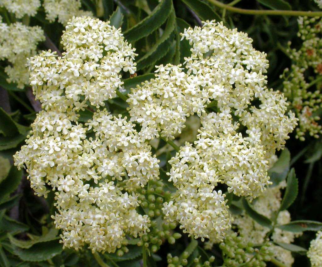
Blue elderberries, native to California, grow throughout the Northwest and are found here in Trinity and Humboldt Counties. These trees are known for their dainty elderflowers, nutritious elderberries, and hard, hollow wood. Indigenous people have long maintained relationships with elderberries. This food source carries medicinal benefits, famously made into elderberry syrup to promote a healthy immune system and fight respiratory illnesses.
Animals, too, enjoy the berries as they ripen in the summer months. Elderberry trees serve as habitat for native bees and the valley elderberry longhorn beetle, because of the spongy tissue of their twigs. This pithiness also makes the wood uniquely amenable to crafting cultural materials, like arrows and flutes. Tribal practices, like cultural burning, ensure longevity and health of elderberry bushes.
What’s in a name?
Local Indigenous languages all have names for elderberries
Ch’iwhiwh
yúxaas
ta’amo’ ‘wer-nerh
luu-k’vm’
In Hupa, ch’iwhiwh means elderberries. Much like German, Hupa words build description. So ‘elderberries’ translates literally to ‘what one sips through,’ and bears information about how the wood was used.
Yúuxas, in Karuk, means elderberry. Yúuxas ánav means elderberry medicine.
In Yurok, elderberries is ta’amo’ ‘wer-nerh. Ta’amo’ meaning elderberry bush, and nerh a shortened form of nerhpery, berry.
In Tolowa, blue elderberry is luu-k’vm’ and red elderberry is chvn-su’lh.
Indigenous plant names reflect the relationship that group has built with that plant. Some ask, why learn a lesser spoken language? Here is one of the many reasons to do so. Indigenous languages have grown around the environments their speakers lived in, and the needs, wants, and interests of those speakers. So being, they are laden with Traditional Ecological Knowledge (TEK). The vocabulary regarding elderberries, for every Indigenous language, expresses a unique worldview. When used, the line between generations of elderberry enthusiasts flows complete.
When and How to Pick
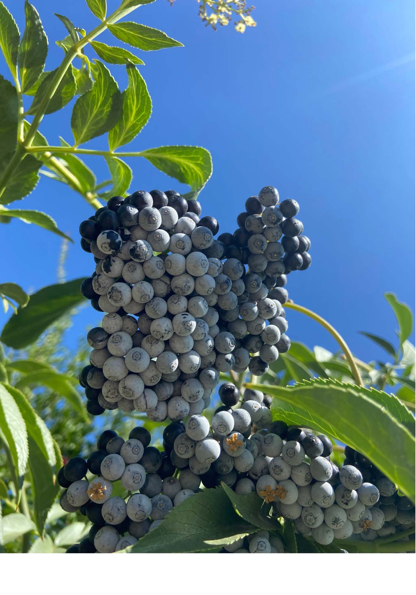
Blue elderberries will flower in the late spring. This is a good time to identify the locations of your nearby trees, as they won’t stick out quite so much once the flowers fall. Flower heads can be clipped and dried. Elderflowers have a “diaphoretic quality which lowers fever (LaPena et al.).” “Fresh or dried, the flowers are steeped to make a potent tea to reduce fever (Karuk Tribe et al.).” It is pertinent to remove all stems, as only the flowers and berries can be consumed. Berries will ripen later in the summer. Typically, they ripen earlier inland and later on the coast.
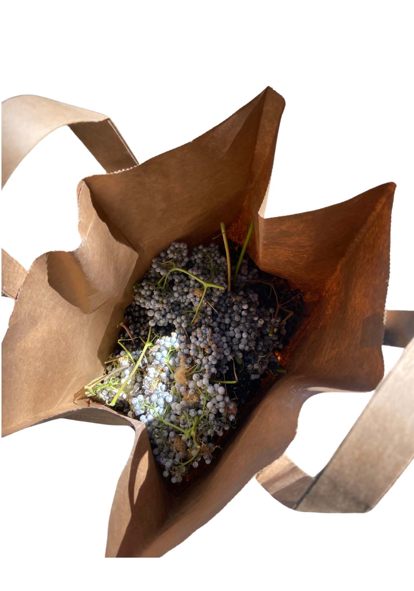
I’m a beginner when it comes to picking elderberries. I’ve learned to only pick them when they’re ripe, when the whole flower head has dark blue or dusty grey berries. Any green berries should not be consumed. Go elderberry picking when there is lots of light and good visibility. To pick berries, it is practical to clip heads of berries and later comb them from their stems. As a general rule, don’t take too many from one tree. Leave some for the birds.
Elderberries can be used in an array of baked goods, syrups, and jams, and can also be dried and eaten. Avoid eating fresh berries as they can cause nausea, easily done as you might find they’re not so sweet.
Works Cited
Karuk Tribe. “Uxraah: Native Edible Berries.” G8L2NativeEdibleBerries_booklet, United States Department of Agriculture, nctcc.org/wp-content/uploads/2017/05/G8L2NativeEdibleBerries_booklet.pdf. Accessed 14 Oct. 2024.
LaPena, Sage, et al. “Indigenous Perspectives on Elderberry Uses – California Elderberries.” University of California Agriculture and Nature Resources, University of California, ucanr.edu/sites/Elderberry/Indigenous/Indigenous_perspectives/. Accessed 14 Oct. 2024.
Lowry, Judith Larner. “Blue Elderberry.” California Foraging, Timber Press, Portland, Oregon, 2014, pp. 57–59.
Unless otherwise noted, all photos were generously provided by Muriel Ammon.
Muriel Ammon
Muriel Ammon (Tsnungwe, Hopi) is a graduate of Dartmouth College and the Southwest Institute of Montessori Studies. Ammon is passionate about Indigenous language revitalization. She has many Hupa language teachers, including her dad, Verdena Parker, and Melodie George-Moore. One of her favorite parts of learning Hupa is connecting to the plants and animals in her backyard.
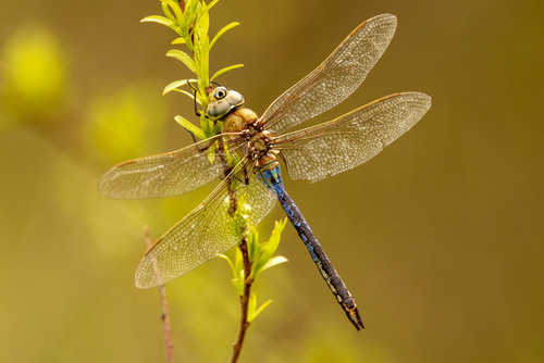
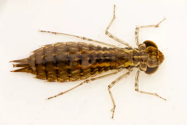
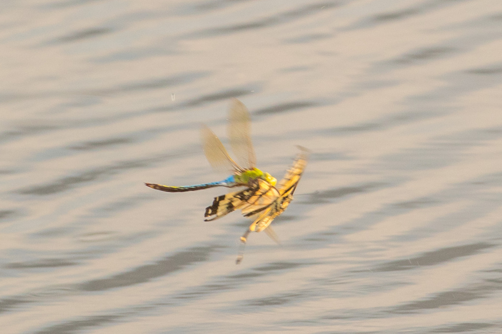
If you’ve been lucky enough to spend time on the Trinity River lately, you will notice a plethora of brassy-green colored dragon flies hovering above the river fervently darting to and fro. The species you are most likely viewing is the common green darner Anax junius. Common is in its name, and that is certainly the case, for this species of dragonfly is the most common and abundant throughout North America. The remainder of its common name, Darner, is given due to its resemblance to a darning needle a blunt-tipped larger needle used for repairing holes or tears in coarse knitted cloth.
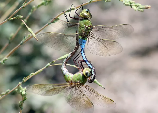
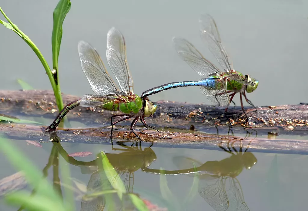
Dragonflies need water to reproduce. In the summer or early fall, common green darners seek riparian areas with slow water so they can mate and lay eggs in water-bound plant material. The female and male mate in an expertly posed “mating wheel” position – where the two are connected at their reproductive centers, the head of the female with the base of the male’s abdomen. The female’s abdomen is wrapped under the male so they can fly through the air, sometimes for several minutes. The female then unwraps her abdomen and lays eggs into the water while still attached to the male.
A female common green darner (left) in tandem position with male (right) deposits eggs. Ken Slade, Source: nps.org
Eggs hatch into macroinvertebrates (tiny aquatic larvae) after about a week incubation period and then go through upwards of a dozen nymphic molts eating aquatic insects, small fish and even tadpoles as they grow. At the end of the transformational nymph stage, Anax junius, emerges from the water to undergo metamorphosis into a dragonfly from a crack in the exoskeleton.
Common green darner aquatic nymph. Douglas Mills. Originally posted by the National Park Service.
Once the wings are developed enough to fly the darner becomes a ravenous forager eating mosquitos, midges, flies, wasps, moths and other flying insects. This dragonfly species has two different population types, resident and migratory. Residents remain in the general area from which they emerge. For residents in the north, the adults mate and lay eggs in late July to August. The resulting offspring hatch and develop to immature dragonflies and then overwinter when temperatures drop.
Adults that migrate tend to arrive in the northern regions in the spring before any of the residents emerge. Migratory adults mate and lay eggs in June. The migratory dragonfly’s development stage is less than that of the resident variety (3-5 months versus the 11 months of the resident) and they do not overwinter as residents do.
Common green darner’s in September on the Trinity River. James Lee, Trinity River Restoration Program
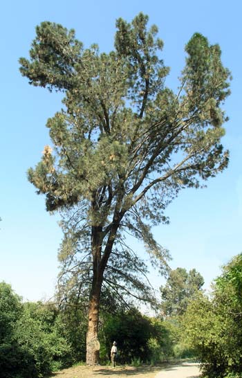
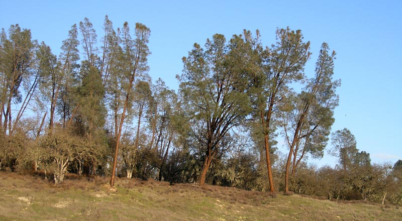
Common names: Grey pine (most common), ghost pine, foothill pine, Sabine pine, bull pine or grey leaf pine.
Adapted to the long, hot, dry summers of our Mediterranean climate, the grey pine is endemic to California and prolificates within the ring of foothills that surround California’s Central Valley. It fairs well in rocky well-drained soils yet also grows in heavy, poorly drained clay soils. The species commonly occurs with Blue Oak (Quercus douglasii) which creates a unique partnership that is described as “Oak/Foothill Pine vegetation” and is indicative of the grey pine which provides a sparse overstory above the canopy of an oak woodland. The partnership in itself is the preferred habitat to black-tailed deer, California quail, as well as mourning dove and describes a characteristic within the California chaparral and woodlands ecoregion, of which Trinity County is part [1].
Photo published on The Gymnosperm Database. A tree at the Rancho Santa Ana Botanical Garden, California [C.J. Earle, 2004.04.13].
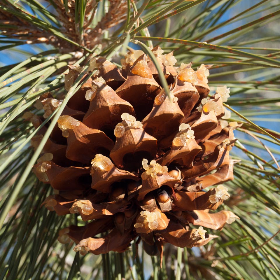
The grey pine is easily identifiable with pale grey-green needles that are sparse and a bit droopy. When looking from afar a grey pine is easily spotted by his smoky, wistful coloration. The structure of P. sabiniana tends to be a bit scrappy with its center trunk splitting sometimes several times, often bending every which way, versus holding a typical stature. Also easily identifiable are the seed cones which are among the largest produced by any pine species, when fresh weighing on average between 1-1.5 pounds. One particular source noted that, “The large, heavy cones resemble footballs covered with wooden spikes. It is best to avoid the pine groves on windy days.” [2] The cones tend to be full of sticky sap and are also home to a plethora of nutritious seeds enjoyed by many animal species, such as Steller’s jay, the scrub jay, grey squirrels and humans. The seeds have an impressive percentage of calories in the form of protein, fat and carbohydrates and provide several essential minerals to those who forage it [3].
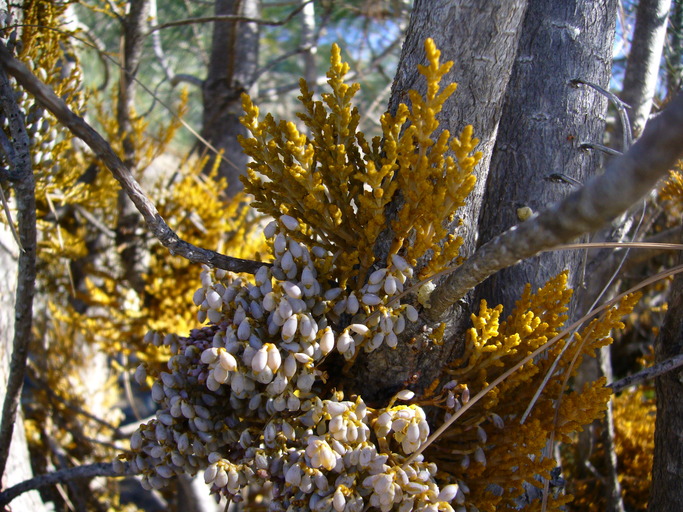
This species is the principal host for the dwarf mistletoe Arceuthobium occidentale a perennial parasitic herb that is native to California [2]. Dwarf mistletoe is considered a disease that the tree can succumb to typically causing reduced tree vigor or death. If you have grey pines near your structures and the parasite is left uncontrolled, infection can increase sixty-fold within a window of 10 years [3].
John Muir, describes this tree in the first chapter of My First Summer in the Sierra: “June 4. … This day has been as hot and dusty as the first, leading over gently sloping brown hills, with mostly the same vegetation, excepting the strange-looking Sabine pine (Pinus sabiniana), which here forms small groves or is scattered among the blue oaks. The trunk divides at a height of fifteen or twenty feet into two or more stems, outleaning or nearly upright, with many straggling branches and long gray needles, casting but little shade. In general appearance this tree looks more like a palm than a pine. The cones are about six or seven inches long, about five in diameter, very heavy, and last long after they fall, so that the ground beneath the trees is covered with them. They make fine resiny, light-giving camp-fires, next to ears of Indian corn the most beautiful fuel I’ve ever seen.”[2]
Photo published on The Gymnosperm Database. Small stand in the southern Santa Lucia Range, California [C.J. Earle, 2007.03.01].
The ethnobotanical uses of the grey pine are impressive with uses ranging from cultural to functional to nutritional. Although there are documented uses for all parts of the tree from sap to needle, primarily the seed gets the most attention. Seeds are noted to be gathered fresh, as well as roasted, boiled or pounded for porridge [5]. The hull of the seed is also used as a bead to decorate traditional dresses used for ceremony. Follow this link to read the lengthy, impressive list of all documented uses.
Photo published on The Gymnosperm Database. Ripe cone in situ; Bodfish area, California [C.J. Earle, 2014.01.17].
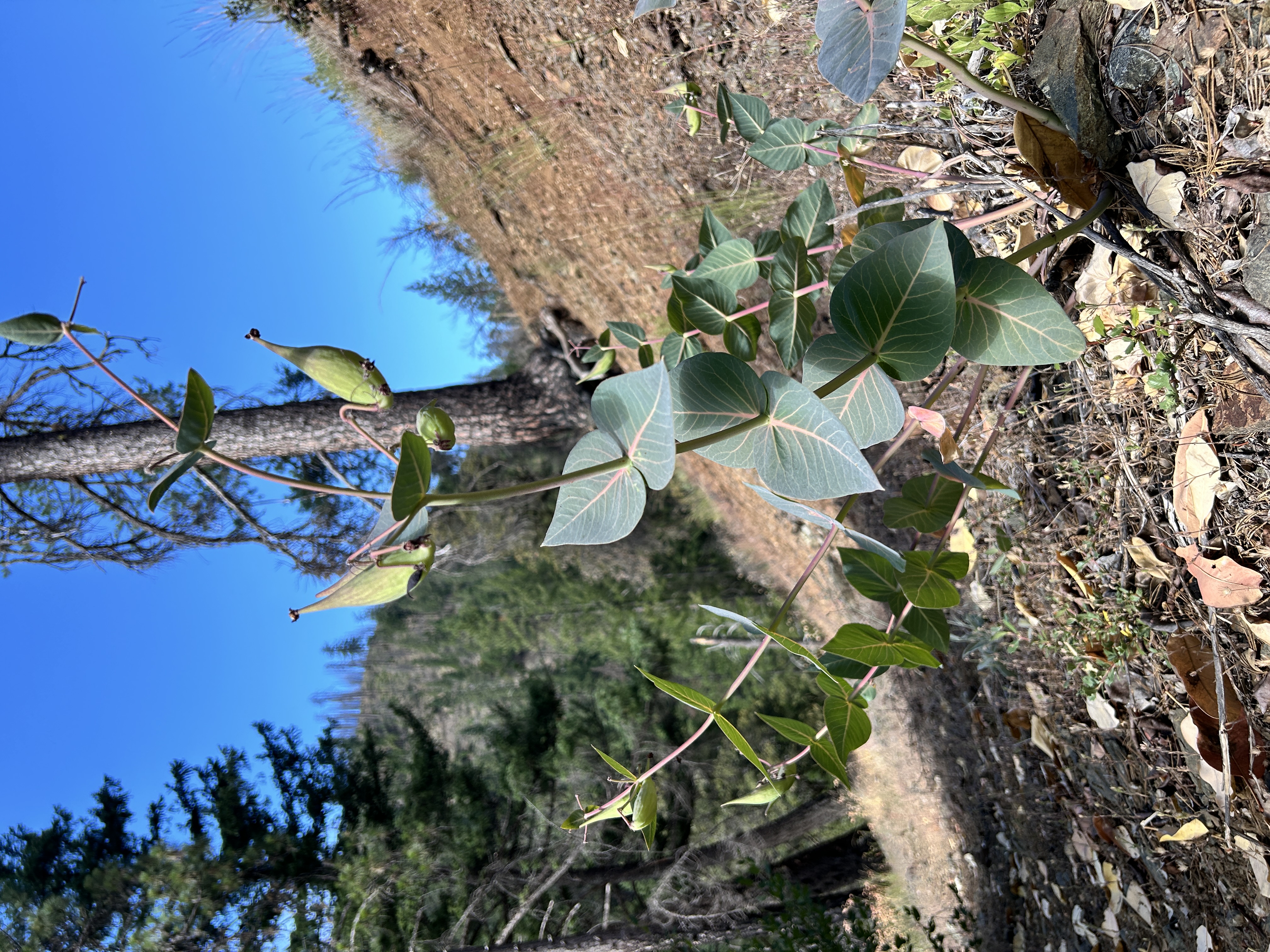
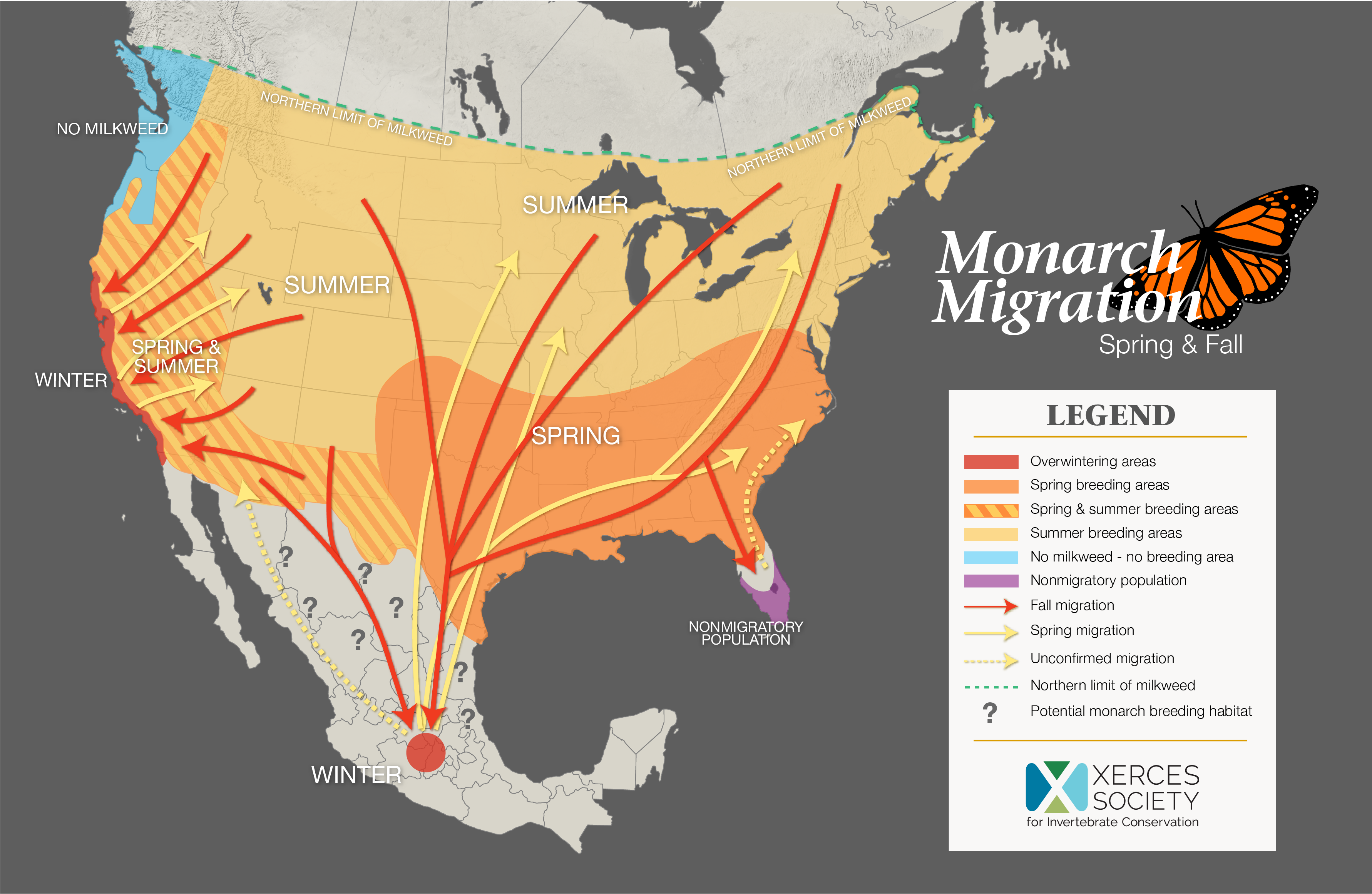
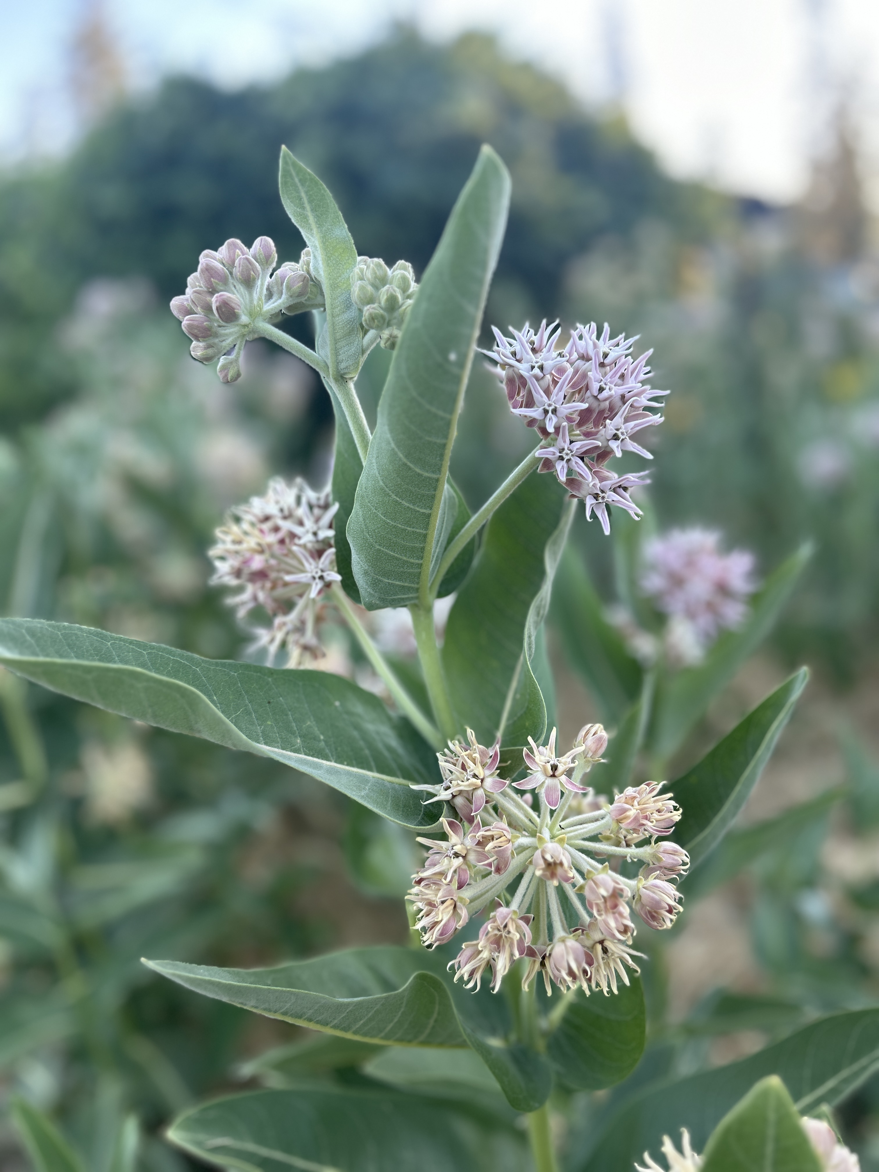
While there are dozens of milkweed species and subspecies in North America, within the Trinity River Watershed there are four documented species, including showy milkweed (Asclepias speciosa) narrowleaf milkweed (Asclepias fascicularis), heart leaf milkweed (Asclepias cordifolia) (DeCamp, 2021, p. 294, 362) and the rare lesser seen serpentine milkweed (Asclepias solanoana) (Kauffman, 2022, p. 155). Each type has unique leaf sets and structure topped with wonderful showy flowers and dramatically large seed pods that propagate via wind in the fall. The flowers are a haven for area pollinators and the plant itself plays a critical role in the majestic monarch butterfly migration. In our region, monarch butterflies, generally choose one type of milkweed, showy milkweed (A. speciosa), to lay their eggs and because of this, the availability and frequency of the plant along the monarch’s migratory path are critical to it’s survival (Western Monarch Milkweed Mapper, 2024).
Photo: Heart leaf milkweed (A. cordifolia) has matured it’s showy seed pods in the Trinity Alps. [Kiana Abel, TRRP]
A monarch’s annual lifecycle goes through upwards of 4 generations during migration. Migration north (and east for western monarchs) happens typically between March and August each year. During migration, an adult female will lay eggs on the underside of young healthy milkweed leaves, hatch, eat, crystallize and repeat. As summer progresses, roughly in the third or fourth generation the western monarch will eventually turn south and west to return to their overwintering sites on the California coast (and in some cases Mexico).
All species of milkweeds are characteristic of the milky sap in their stems and leaves which contain a lethal brew of cardenolides (heart poison). If grazed, animals and insects are served a warning with distasteful, hairy leaves. If ingested, a grazer is confronted with vomiting and potentially death in higher doses. The negative effect on agricultural livestock like sheep and cows led farmers and agriculturalists toward eradication efforts. Over time, the combination of increased land use and herbicide led to a significant decline in available milkweed, with monarch populations following suit.
Showy milkweed (Asclepias speciosa) cultivated in the Weaverville Community Garden. [Kiana Abel, TRRP]
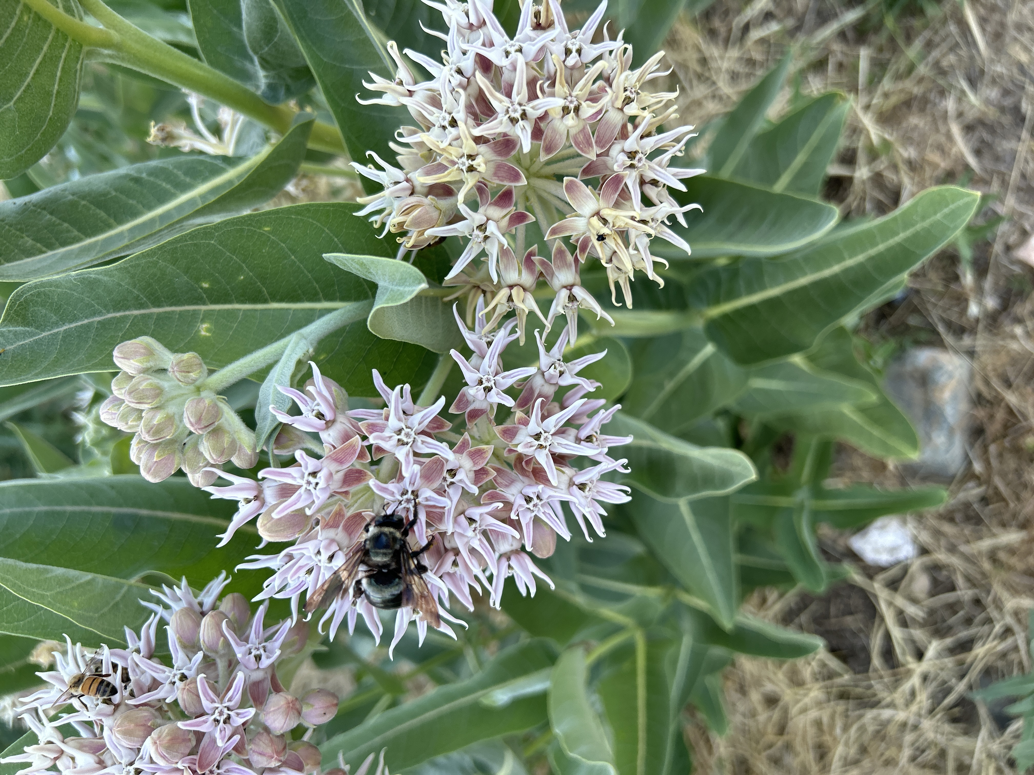
The handful of insects that do eat the plant are all incredibly colorful which in-turn serves as a warning to their predator’s (Monarch Joint Venture, 2024). If a monarch caterpillar were to be eaten it’s predator will encounter a nasty taste and hopefully drop it’s prey. For the majority of insects like bees, moths and other butterflies the main attraction to milkweed is the flower which provides nectar during a time in the summer when most other flowers have spent. For each type of milkweed found, the flowers are showy, intricate and are certainly worth a close-up look.
Showy milkweed (Asclepias speciosa) a pollinators delight. [Kiana Abel, TRRP]
Milkweed has proved useful to people as well. Ethnobotanists have documented historic and current use of the plant in fiber, food and medicine in the United States and Canada. Milkweeds supply tough fibers for making cords, ropes as well as for course cloth. Native Californian tribes use the plant for all the purposes listed above. In one documented case of a Sierra Miwok woven deer net, the trap measured 40 feet in length and contains some 7,000 feet of cordage, which would have required the harvest of 35,000 plant stalks. Among Californian Native tribes, the most common documentation of use was to obtain a kind of chewing gum from the sap of showy milkweed (A. speciosa). The sticky white sap is heated slightly until it becomes solid, then added to salmon or deer gristle (Stevens, M., 2006).
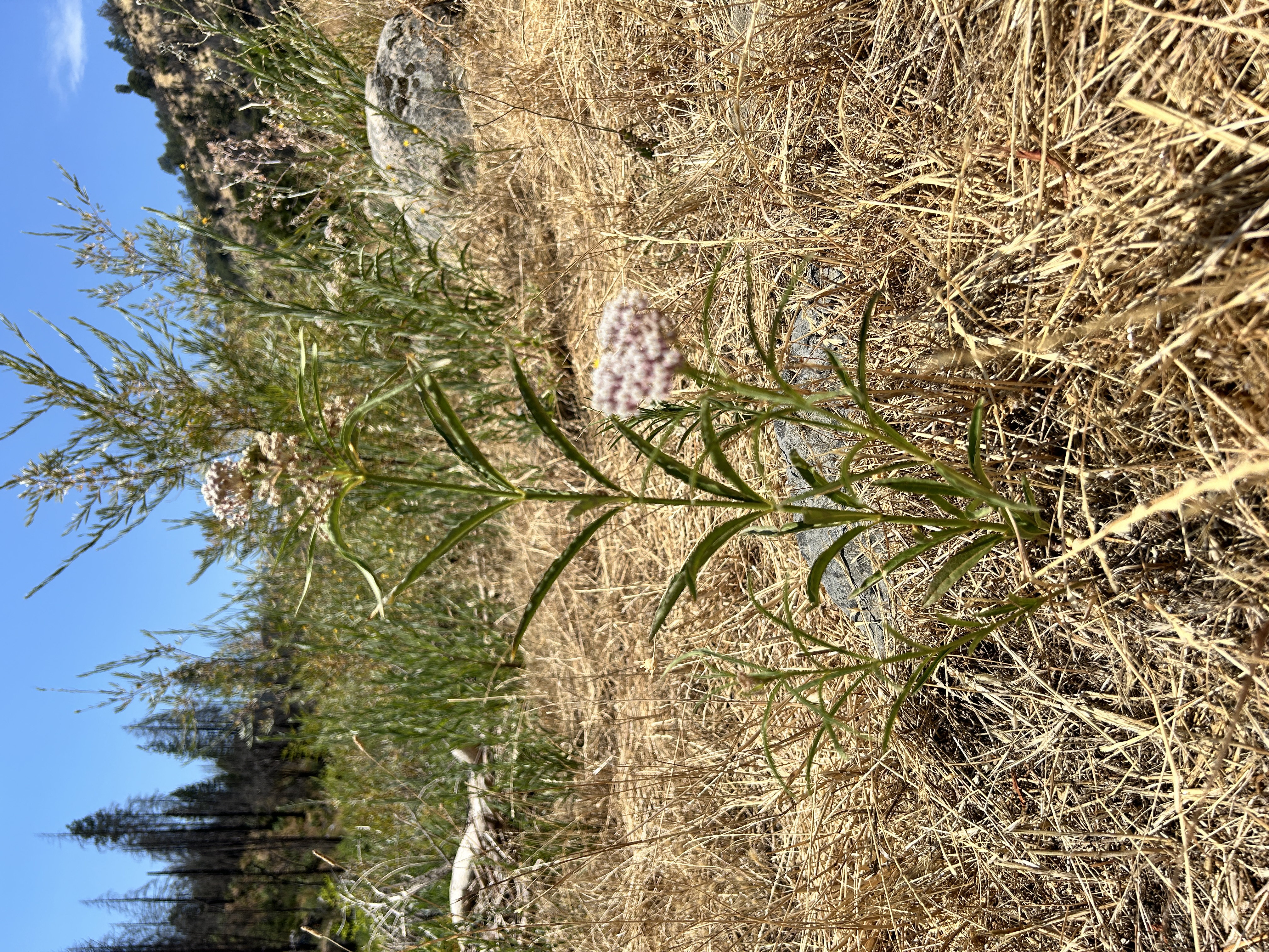
Narrowleaf milkweed (A. fascicularis) found near the Trinity River in Big Flat in July 2024. [Kiana Abel, TRRP]
The decline of wild milkweed plants as well as the majestic monarch butterfly has spawned a cultivation movement to encourage everyday gardeners to plant. If you reader, would like to cultivate milkweed in your pollinator garden, make sure to plant it in a location where it can expand. In suitable conditions, milkweed can outcompete other plants and on occasion infrastructure such as plant boxes or walkways. A second consideration is where the location of where you’d like to plant in accordance with the migratory path of the monarch. If you are in a costal overwintering area, it is more beneficial to monarchs to plant nectar plants versus nursery plants. A planting of A. speciosa may falsely signal that they are in a location fit for reproduction leading to a disruption in their migration cycle.
When you’ve picked the best species for your area you can propagate milkweed from seed or rhizome. Collect seeds from pods once they have ripened, but prior to splitting open. Experienced cultivators planting in high elevation or colder climates have documented higher success rates with seed by using a cold treatment for three months and then planting directly into the ground the first fall after collection (Stevens, M., 2006). Propagation by rhizome is also easy and reliable. Create cuttings when the plant is dormant and make sure the rhizome has at least one forming root bud. Success is also dependent on on timing. Harvest or divide plants at the beginning of the rainy season and plant them in the ground by late fall so they can develop enough root growth to survive the winter. Irrigation in the first year will improve survival, and by the second year the root system should be well enough established so plants will survive on their own (Stevens, M., 2006).
Asclepias sp. Milkweed Native American Ethnobotany Data Base. A Database of Foods, Drugs, Dyes and Fibers of Native American Peoples, Derived from Plants.